As California works toward ambitious wildfire and landscape resilience goals, transparency is critical to success. Using science and data to track the health of our fire-adapted ecosystems, CNRA is leading a long-term statewide forest ecosystem monitoring and assessment initiative. This effort will greatly improve understanding as to how forest management and harvest practices impact ecosystem health. By integrating interagency data and remote sensing from state and federal resource programs, CNRA is establishing a spatially explicit, consistent approach to track ecosystem conditions over time at a watershed scale. Along with other state efforts to monitoring fire-adapted landscapes, CNRA’s assessments will allow the State and federal agencies to evaluate how their programs have affected entire landscapes.
Remote Sensing for Public Safety & Natural Resource Management
With $30 million provided by the Legislature, CNRA has invested in publicly available remote sensing data and analytics for use in ecosystem health and wildfire management, and related public safety and science applications across the state’s fire-prone landscapes. These data and analytics are critical for natural resource management and public safety, and help fulfill multiple legislative mandates that require state agencies to evaluate the impact and effectiveness of landscape resilience investments being made across California.
The investment CNRA has made will revolutionize the way the State uses the latest technology to fight the negative impacts of extreme environmental variability and catastrophic wildfire. The data and insights gained from these investments will enable California to be on its front foot in understanding the impact and effectiveness of the state’s multibillion dollar wildfire resilience investments. CNRA is taking a one-time investment and creating an enduring program of work for the operational use of multiple agencies and the public.
The following is a list of investments within CNRA’s Remote Sensing Portfolio aimed at delivering new remote sensing acquisitions, processed data products and analytics for application, including:
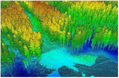
- LiDAR: In partnership with the US Geological Survey’s 3D Elevation Program and other entities, CNRA has contributed to the collection of over 40 million acres of new LiDAR covering large swaths of Northern California and the Sierra Nevada, and filling data gaps up and down the state. Processed data products will be generated to directly enhance our knowledge of vegetation and landforms in some of the most rugged and fire-prone portions of the state in support of wildfire incident response, strategic planning, and management
- Wildfire, Ecosystem Resilience, and Risk Assessment Project (WERK): In partnership with other state and federal agencies, the CA Air Resources Board (CARB), CNRA, and NASA Earth Exchange at Ames Research Center are developing high-resolution remote sensing-based vegetation mapping and assessment products tailored to California to equip public health and safety programs focused on forest health and wildfire resilience. Covering the State’s shrublands, grasslands, forests, and urban forests, the WERK project will generate wall-to-wall maps of change detection and attribution, land cover classification, individual tree detection, and built structures. Assessments within and between the data products will support programmatic evaluation of management effectiveness, including multi-billion-dollar investments in fuel reduction and forest health treatments. The WERK project has been built to last: leveraging its newly equipped high-performance computing cluster, CARB’s Nature-Based Strategies Section will update these data on behalf of agencies and the public moving into the future.
To read in-depth on this strategic investment, Click Here
- Geospatial Treatment Tracking System: Building on efforts catalyzed by the Governor’s Wildfire and Forest Resilience Task Force to establish an interagency geospatial tracking system and dashboard for fuel reduction activities statewide, CNRA will expand the interagency geospatial treatment tracking system to enable the inclusion of management actions across all lands contributing to the State’s broader resilience targets. These data are essential to incident response during disasters as well as strategic planning efforts across state and federal lands.
- Post-Fire On-Demand Imagery: CNRA and the California Geological Survey are collecting and processing on-demand remotely sensed data and imagery to provide timely public safety information following a wildfire. Emergency managers can use the data to assess post-wildfire geologic and hydrologic hazards on state and federal responsibility areas.

- Integrated Observatory for Redwood Forest Health: In partnership with UC Davis, Lawrence Berkeley National Laboratory, CA Air Resources Board, and CAL FIRE, CNRA is installing the first-of-its-kind redwood forest observatory consisting of two eddy covariance flux towers in the California redwood forest ecosystem. Instruments on these towers will provide real time understanding of how redwoods respond to climate change, wildfire, and management to help land managers protect this iconic forest ecosystem undergoing rapid change.


