California Aqueduct Subsidence Program
Subsidence and the California Aqueduct
Subsidence, or the sinking of land, has been documented throughout California for almost a century. Prior to the construction of the aqueduct in the mid-1960s, portions of land near the aqueduct dropped between 20 and 30 feet. While rates of subsidence stabilized for a few decades after original construction, the aqueduct has sustained an alarming and unprecedented increase in subsidence rates. In the three years of the drought from 2013 through 2016, areas of the aqueduct sunk nearly three feet.California Aqueduct
The California Aqueduct delivers water to 27 million people throughout the state, supplying water for agriculture as well as municipal uses. The Aqueduct was built by California’s Department of Water Resources (DWR) and the U.S. Bureau of Reclamation. After construction, the operation and maintenance of the facilities were managed by DWR.
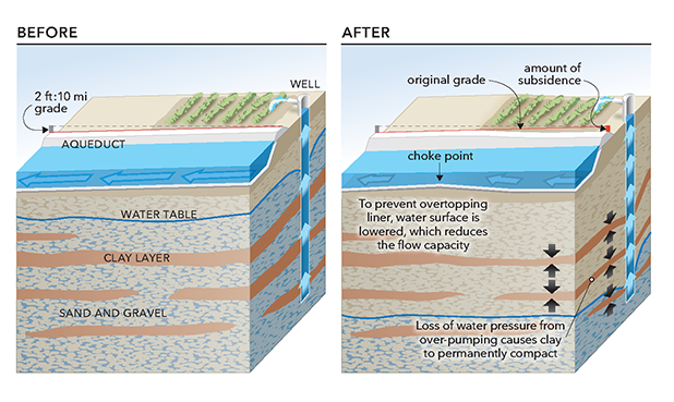
The Aqueduct is broken up into pools, which are roughly 10 miles long in the central valley. At the end of each pool, a gated check structure controls the flow from one pool to the next, as well as the water surface elevation with the pool. The numbering of a check structure is associated with its upstream pool. Each pool, being roughly 10 miles long, has an elevation fall of 2 to 4 feet, which is used to move the water. Changes to this profile, through subsidence, has caused decreases in the flow capacity of the system, as well as operational difficulties.
Causes of Subsidence
Groundwater pumping has long been understood as a primary cause of this alarming trend, and typically ramps up during extended drought periods. The effects of climate change are predicted to exacerbate this trend. In addition, the recent conversion of row crops (often fallowed in dry years) to orchards and vineyards (cannot be fallowed in dry years) has resulted in more subsidence when surface water is unavailable during dry periods.Impacts of Subsidence
Increased water delivery costs: Subsidence has reduced the flow capacity of the aqueduct in areas. To maintain water deliveries, operators must move water more often during on-peak hours, which increases operating costs and limits the use of renewable energy sources. Since the SWP is the largest user of electricity in California, this impacts all Californians.Decreased reliability: As the aqueduct sinks, there is increased risk that water will go over the aqueduct liner, which could result in erosion or damage to other delivery structures, delivery losses, flooding, and require emergency outages of the aqueduct.
Increased operations and maintenance: To address subsidence, DWR will need to undertake significant modifications and repairs to its conveyance facilities and structures.
The California Aqueduct Subsidence Study: Supplemental Report presents new data compilation, analysis, and modeling to supplement the 2017 California Aqueduct Subsidence Study report.
This supplemental report addresses land use within a 10-mile-wide study corridor centered on the California Aqueduct in the San Luis Field Division and the San Joaquin Field Division south of San Luis Reservoir; subsidence in the Lost Hills oil filed west of the aqueduct; modeling of aqueduct performance using the U.S. Army Corps of Engineers’ Hydrologic Engineering Center’s River Analysis System hydraulic model; and predictions of future subsidence.
To receive a copy of the original report, or if you need additional information, refer to the listed contact information on this page.
Contact Information
California Aqueduct Subsidence Program
California Department of Water Resources
Division of Engineering #6
715 P Street
Sacramento, CA 95814
Contact: CASP@water.ca.gov
Subsidence Documents:
- Long-Term Rehabilitation Capital Cost Estimate Report (January 2026)
- Preliminary Assessment of Susceptibility - San Luis Canal and the CA Aqueduct - Pool 14 through 40 (September 2025)
- Probabilistic Subsidence Forecast for the California Aqueduct Subsidence Program, San Joaquin Valley, California Revision 1 (October 2024)
- Hydraulic Conveyance Capacity Report (December 2023)
- California Aqueduct Hydraulic Model Development (December 2023)
- California Aqueduct Subsidence Study: Supplemental Report (March 2019)
- California Aqueduct Subsidence Study: Original Report (July 2017)