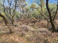
Lake Oroville Update - July 31, 2026 from the California Department of Water Resources, detailing fuel load reduction projects in collaboration with CAL FIRE.
Published:
Lake Oroville Update - July 31, 2026 from the California Department of Water Resources, detailing fuel load reduction projects in collaboration with CAL FIRE.
To protect the State Water Project, the California Department of Water Resources has a three-pronged stategy to combat the spread of Golden mussels in the Delta and all of California.

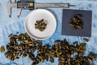
Loss of habitat and the effects of climate change are putting turtles at risk in California. At the Clifton Court Forebary, the California Department of Water Resources is monitoring this species that is listed as threatened under the Endangered Species Act.

Lake Oroville Update - July 24, 2026 from California Department of Water Resources. Featuring paving work along the Thermalito Afterbay Dam Crest.
Lake Oroville Update - July 17, 2026 from California Department of Water Resources. Featuring the construction of salmon habitat improvement in the Feather River.


Scientists at the California Department of Water Resources are finding the Delta’s most elusive residents means digging deep down into the microscopic traces they leave behind.

Lake Oroville Update July, 3 2026, detailing Wildlife Safety at the State Recreation Area and free fishing day!

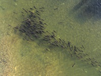
This annual change in regulations is driven primarily by what scientists know about the life cycles and movements of native fish species that include Delta smelt, longfin smelt, steelhead, and Chinook salmon.
