Lake Oroville Community Update - December 10, 2021
Lake Oroville at Oroville Dam Boat Launch at an elevation of 659.98 feet, 28 percent of total capacity or 54 percent of average capacity for this time of year, on October 29, 2021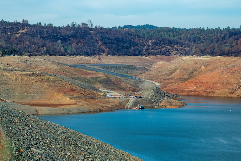
State Water Project Allocation
The Department of Water Resources (DWR) announced the initial State Water Project (SWP) allocation for 2022 on Dec. 1, along with several steps to manage the state’s water supply in anticipation of a third dry year with reservoirs at or near historic lows. The Dec. 1 allocation will focus on the health and safety needs of the 29 water agencies that contract to receive SWP supplies. The SWP will not be planning water deliveries through its typical allocation process until the state has a clearer picture of the hydrologic and reservoir conditions going into the spring. (Hydrology is the study of movement of water in relation to land – including water from precipitation and snowmelt.)
DWR is focused on prioritizing water supply in four categories: water for health and safety needs and Delta salinity control; water for endangered species; water to reserve in storage; and water for additional supply allocations if the hydrology allows. Water in Lake Oroville will be reserved to maintain Delta water quality, protect endangered species, and meet senior water right needs.
Beyond minimal exports to meet South Bay health and safety needs, water stored in Lake Oroville will be used for south of Delta deliveries only if hydrology conditions improve. South of Delta deliveries will be met with water available from the Delta as well as water stored in San Luis Reservoir. The full news release can be viewed on the DWR News Releases webpage.
Oroville Dam Citizens Advisory Commission Public Meeting
The California Natural Resources Agency (CNRA) held its ninth Oroville Dam Citizens Advisory Commission meeting on Dec. 3, 2021. The online public meeting included presentations about downstream flood management and preparedness as well as an update on the Water Control Manual from a representative of the U.S. Army Corps of Engineers. Members of the public also offered comments and asked questions. The Citizens Advisory Commission is a forum to provide public feedback from the communities surrounding Oroville Dam. The meeting transcript and presentations will be available on the Commission’s website in the coming weeks, visit https://bit.ly/OrovilleCAC.
New Invasive Plants Discovered
Environmental scientists with the Department of Water Resources (DWR) Oroville Field Division have discovered a new aquatic invasive plant in the Feather River downstream of Oroville. The new floating aquatic plant is the South American spongeplant (Limnobium spongia), previously known from the Sacramento River and the Sacramento-San Joaquin Delta. This is the second new, high-rated invasive plant species DWR has discovered in the Feather River in the last three years. In 2019, alligator weed (Alternanthera philoxeroides) was found adjacent to the Feather River Outlet Boat Ramp. Neither of these species were previously known in Butte County but have been expanding in recent years across California.
Aquatic invasive species (AIS) move from one area to another via watercraft, personal water gear, pets who have entered the water, and by wildlife. Cleaning and drying anything that came in contact with water (including pets and clothing) will help prevent the spread of AIS.
You can help minimize the spread of AIS by thoroughly inspecting all equipment after leaving a waterbody; clean any visible mud and plants from watercrafts, equipment, and personal gear; and drain water from all equipment, including bait buckets, and ballast tanks.
Invasive plants can de-stabilize dissolved oxygen cycles needed by fish and aquatic organisms, crowd out native plants, shade out crucial shallow-water fish habitat, obstruct waterways and navigational channels, and block agricultural and municipal water intakes.
Loafer Creek Fuels Management
Crews from CAL FIRE’s Butte Fire Center, along with crews from California Conservation Corps and Butte County Sheriff Office, are performing various fuel reduction projects using heavy equipment, hand cutting, chipping, and pile burning of prioritized overgrown vegetative areas within the Federal Energy Regulatory Commission (FERC) project boundary of DWR’s Oroville-Thermalito Complex.
Hikers and equestrian users of the Roy Rogers Trail in the Loafer Creek Recreation Area, visitors to the area, and motorists along Highway 162 are advised to be mindful of safety when near work zones.
Oroville Recreation
Bidwell Canyon’s Stage III concrete boat ramp and the single-lane gravel boat ramp at Oroville Dam’s Spillway Boat Ramp area are open. The Spillway ramp will continue to be open as conditions permit. Boaters on the lake are advised to be aware of unexpected shallow water, obstruction hazards, and floating debris.
The Lime Saddle Marina is open for customer access, but with very limited services due to damage caused by the October storm event. At this time, the boat ramp remains out of the water. Access to boats and houseboats at both Bidwell Canyon and Lime Saddle marinas should be coordinated through the marina prior to arrival by calling (530) 589-9175 or by utilizing the shuttle service at Bidwell Canyon Marina.
The Lake Oroville Visitor Center is open to the public on Tuesdays, Wednesdays, and Thursdays from 9 a.m. to 5 p.m. Visitors can tour the center’s exhibits on the construction of Oroville Dam – the tallest dam in the country; the State Water Project which provides water to 27 million Californians and 750,000 acres of farmland; a new interactive water education exhibit, and much more. Please contact the VC Guides at (530) 538-2219 for more information.
Numerous Day Use Area (DUA) facilities with picnic tables and restrooms at Lake Oroville State Recreation Area (LOSRA) are open 8 a.m. to sunset. Bidwell, Lime Saddle, and Loafer Creek recreation areas are open 24 hours. The Oroville Dam Crest Road across Oroville Dam is available 5 a.m. to 11 p.m. daily with the spillway trailhead and boat launch open from 6 a.m. to 8 p.m. The top of the dam is open to pedestrians and bicyclists 24-hours a day.
DWR’s new trail maps of over 97 miles of trails available to equestrians, bicyclists, and hikers wishing to explore Oroville’s natural beauty in the cooler fall weather are available at many Oroville locations, including Lake Oroville State Recreation Area (LOSRA) kiosks, Oroville Wildlife Area office on Oro Dam Boulevard West, the Oroville Area Chamber of Commerce, and Feather River Recreation and Parks District.
Visit the California Parks LOSRA webpage for current information on facility status and campground reservations. An interactive map of recreation facilities in DWR’s Oroville-Thermalito Complex is available on DWR’s Lake Oroville Recreation webpage. Information about the 11,000-acre Oroville Wildlife Area is available on the California Department of Fish and Wildlife webpage.
Current Lake Operations
The elevation of Oroville’s reservoir is about 673 feet elevation and storage is about 1.06 million acre-feet, which is 30 percent of its total capacity and 59 percent of historical average. Heavy precipitation in Oroville and snow accumulation in the higher elevations are forecasted for the Feather River Basin beginning Sunday and extending into Monday with continuing snow showers into the higher elevations mid-week. The Feather River basin may see 5 to 7 inches as a result of these storms. Temperatures will range in the 20s and 30s in the higher elevations and upper 40s and low 50s in the valley.
Inflows to Lake Oroville have been ranging around 500 to 1,000 cubic feet per second (cfs) and are expected to increase early next week in response to the heavy precipitation. Current forecasts indicate potential inflows of about 10,000 cfs (subject to change based upon on actual weather and soil conditions). At 30 percent capacity, there is sufficient storage to manage these inflows.
Total flows to the Feather River are at 1,500 cubic feet per second (cfs) for meeting downstream water quality and flow requirements. Flow in the low-flow channel, through the City of Oroville, is 650 cfs and flow through the Thermalito Afterbay Outlet is 850 cfs. Releases are assessed daily.
The public can track precipitation, snow, reservoir levels, and more at the California Data Exchange Center at www.cdec.water.ca.gov. Lake Oroville is identified as “ORO”.
All data as of midnight 12/09/2021
Know someone who would like to receive Community Updates? They can email their request to oroville@water.ca.gov.