National Hydrography Dataset Stewardship Program
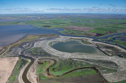
Aerial view at 1500 feet looking north of the Dutch Slough Tidal Marsh Restoration Project the construction site, in the Sacramento-San Joaquin Delta near Oakley, California.
The National Hydrography Dataset (NHD) and Watershed Boundary Dataset (WBD) are used to portray the flow of surface water on the The National Map which is maintained by the United States Geological Survey (USGS). The NHD represents the drainage network from headwaters to the ocean with features such as rivers, streams, canals, lakes, ponds, coastline, dams, and stream gages.
The WBD represents drainage basins in eight different coincident sizes. These features are stored in a file geodatabase format for use in a geographic information system. The NHD and WBD are ingredient datasets for NHD Plus High Resolution, a national, geospatial model of the flow of water across the landscape and through the stream network.
DWR is the steward for NHD and WBD in California. We work with stewardship partners to edit and improve NHD and WBD using USGS’ tools and specifications as well as business rules we have adopted for California. The editing work is performed at the 1:24,000 scale consistent with the national database. Our improvements are sent to USGS, and the most current dataset is available for direct download or linking to web services on the USGS National Hydrography website.
Additional resources, including derivative mapping products and the California Business Rules, may be discovered on the California Natural Resources Agency Open Data website. We welcome new stewardship partners who can contribute local knowledge of surface water locations and characteristics to join us.
The authoritative geospatial representation of California’s watershed boundaries for many years was the dataset known as CalWater. DWR was the lead for the multi-agency effort to maintain CalWater. In 2017 DWR sent a letter to the signers of the original CalWater Memorandum of Understanding declaring that the NHD’s Watershed Boundaries Dataset will be the actively maintained authoritative dataset of California’s watersheds moving forward.
NHD Stewardship progress is reported to the California GIS Council at their regular meetings, and are posted on the Hydrography Workgroup page of the Council website.
Errors in the dataset may be reported to USGS using the Markup Application or by contacting the lead California steward at nhd_stewardship@water.ca.gov.
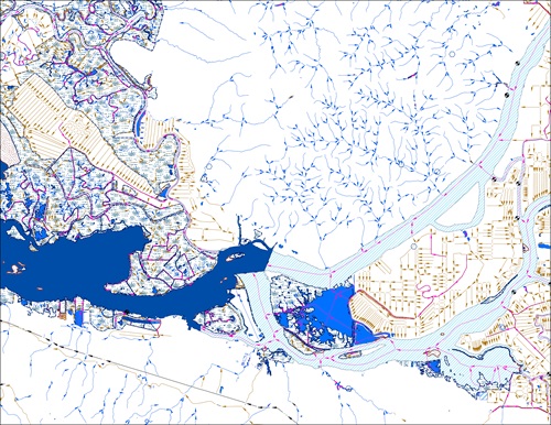
A view of the various water features surrounding the confluence of the Sacramento and San Joaquin Rivers as they flow into Suisun Bay is portrayed here in the National Hydrography Dataset.