DWR is Committed to Building a Climate Resilient Delta to Benefit People, Farms, and Fish
A drone view of the Dutch Slough Tidal Marsh Restoration Project site, located in the Sacramento-San Joaquin Delta near Oakley, California. Photo taken June 6, 2025.
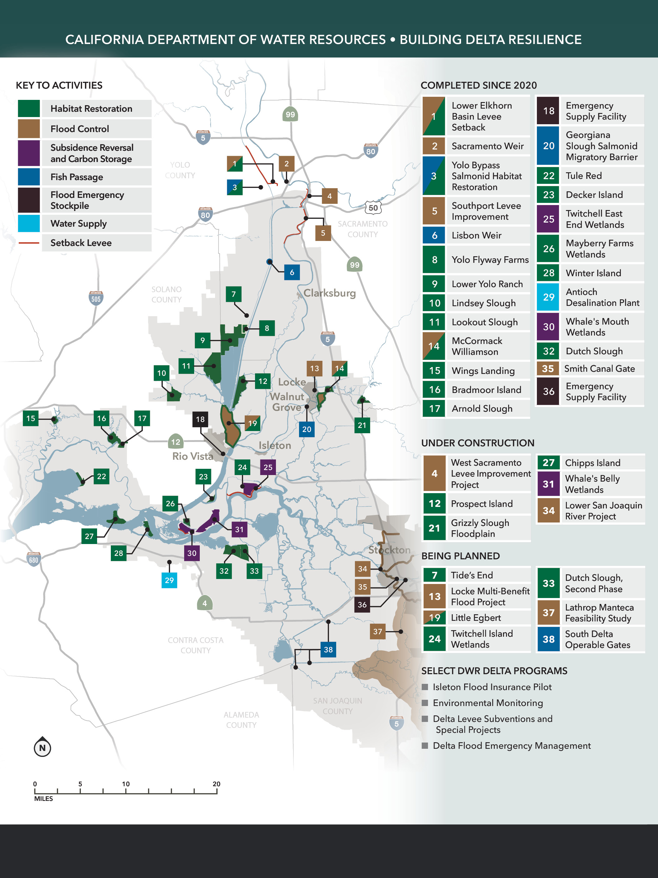
The California Department of Water Resources (DWR) is committed to building climate resilience in the Sacramento-San Joaquin Delta. A newly released map from DWR shows dozens of projects and programs aimed at building Delta Resilience.
The Delta faces climate risks like no other region of California. Runoff from 40 percent of California’s land mass flows to the Delta, while tides move inland from San Francisco Bay. Once a large tidal marsh, huge amounts of fresh and saltwater ebb back and forth across this estuary twice a day. Farms, historic communities, highways, railroads, and other assets in the Delta are protected by hundreds of miles of earthen levees. In the central and western Delta, some islands sit 20 feet below sea level because the peat soil there disappears when dried and tilled; the deeper an island subsides, the greater the risk of levee failure. Every Delta island has flooded at least once since farmers began reclamation in the late 1800s. Climate projections show the future will bring greater-intensity storms and peak tides that will test levees and threaten wildlife habitat that has been restored. Should Delta levees collapse, the flood damage could extend well beyond lives and property in the Delta. Two of every three Californians get some of their water supply from the Delta. The rush of water onto flooded islands could draw ocean water deep into the Delta, interrupting water diversions for months or years, until enough fresh water could be released upstream to flush out salt. Even the most gradual expressions of sea-level rise will eventually transport more salinity into the Delta. The tradeoff to manage salinity will reduce state water supplies.
Since its creation in 1956, DWR has been working to minimize Sacramento-San Joaquin Delta flood risks. Since the 1990s, DWR also has been working to restore habitat in the Delta — the largest West Coast estuary and an important corridor for migratory fish — in a way that buffers sea-level rise. More recently, DWR has focused on protecting Delta communities with wetland expansions that convey and absorb high flows; building back subsided Delta soils with rice and tule plantings that also sequester carbon; clearing obstacles to fish passage; and using gates to help control salinity. DWR works closely with the dozens of local reclamation districts that maintain Delta levees and has invested more than $1 billion in Delta levees since 2000. DWR preparations for Delta flooding are extensive, including tabletop and functional exercises, grants to strengthen local emergency response, flood material stockpiles, and a pilot flood insurance program for the river town of Isleton. DWR coordinates with dozens of agencies to conduct environmental monitoring and research.
DWR will continue to work with local, state and federal partners to develop and create Delta projects and policies that deliver a more reliable statewide water supply and a healthy and protected ecosystem, while protecting and enhancing the unique characteristics of the Delta as an evolving place.