Lake Oroville Community Update - May 19, 2023
Driftwood is collected and towed in pods with boats throughout Lake Oroville in Butte County, California.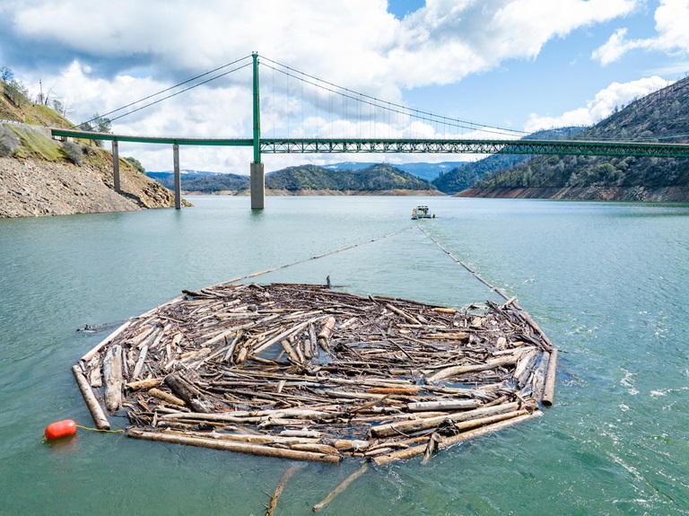
Lake Oroville Water Releases Continue
The Department of Water Resources (DWR) continues to make releases from Lake Oroville using the main spillway at Oroville Dam. Ongoing releases ensure continued storage space in Lake Oroville for spring runoff from snowmelt and are closely coordinated with the U.S. Army Corps of Engineers and downstream water operators.
Total releases to the Feather River amount to 13,000 cubic feet per second (cfs) with 5,650 cfs being routed down the low-flow channel which flows through the City of Oroville. An additional 7,350 cfs is being released from the Thermalito Afterbay River Outlet, located 5 miles downstream from Oroville. DWR continues to closely monitor lake levels and will adjust releases accordingly to optimize operations for water storage and environmental protection while allowing for carryover storage into next year.
Driftwood and other floating debris at the state recreation area are expected due to continued water inflows from tributaries and a high lake level, in combination with past wildfires impacting the watershed. Since January, State officials and marina partners have been collecting, containing, and pulling pieces of wood out of the lake and away from boat launch ramps using boom lines. However, boaters, water skiers, and other water recreationists should take precautions when operating boats on Lake Oroville and should remain alert for floating debris.
Since Dec. 1, Lake Oroville’s storage has increased approximately 230 feet and gained over 2.4 million acre-feet of water. Lake Oroville is currently at 96 percent capacity and is expected to reach full capacity this spring. The Lake Oroville reservoir is the largest storage facility in the State Water Project (SWP) and supports environmental and water delivery needs to 27 million Californians and reduces flood risks to downstream communities.
Walk Into Wellness
Join the California Department of Parks and Recreation (State Parks) for a series of guided, meditative walks around the Lake Oroville State Recreation Area that promote health and wellness. These free walks focus on calming reflections and enlightening exercises while immersed in the beauty of nature. Sturdy shoes and a water bottle are recommended for participants. Wellness walks are scheduled from 8 a.m. to 10 a.m. on the following dates and locations:
- Saturday, May 27: Lake Oroville Visitor Center (917 Kelly Ridge Road, Oroville); meet at gravel lot near the Visitor Center gate
- Saturday, June 10: Loafer Creek; meet at the Loafer Creek Day Use Area
- Sunday, July 16: Bidwell Canyon; meet at the Toll House Museum
Hours Extended for Spillway Day-Use Area
As the summer months approach and daylight hours linger, the Spillway Boat Ramp and Day Use Area is now open from 5 a.m. to 11 p.m. All vehicles and trailers are subject to inspection by the California Highway Patrol (CHP) for security purposes. There are five other boat ramps at Lake Oroville that are open 24 hours a day and do not entail CHP inspections: Bidwell Canyon, Loafer Point, Loafer Creek, Lime Saddle and Enterprise.
Water Safety Month
The State Water Project’s (SWP) reservoirs located throughout California will welcome the upcoming summer months with high water levels. Heavy storms this past winter will also bring fast flows and cold temperatures to rivers and streams as mountain snow melts. When recreating at SWP facilities, you should always keep water safety a top priority and stay alert for cold, fast, and fluctuating water conditions.
As part of Water Safety Month, keep these water safety tips in mind to have a fun and safe summer:
- Wear a life jacket
- Swim in safe or designated areas only and near a lifeguard
- Swim with a buddy
- Be aware of drop-offs into deep water
- Watch for hidden debris and slippery rocks
- Look before you leap or dive
- Check for algal bloom updates
- Know your GPS location
Lake Oroville, the SWP’s largest reservoir, has more than 167 miles of shoreline and is a perfect location for boating, fishing, skiing, wakeboarding, swimming or paddleboarding. Those seeking to spend more than a day relaxing on the lake can rent houseboats from local marinas, stay at one of three campgrounds at the lake, or reserve floating campsites through State Parks.
Oroville Recreation
DWR, State Parks, and CDFW maintain over 92 miles of trails in the Oroville area. Paved trails at the Lake Oroville Visitor Center, Spillway Day Use Area, and at the North Forebay Day Use Area offer accessible trails with only slight elevation changes. Other trails, such as the Brad Freeman Trail near Oroville Dam, offer steep elevation changes to challenge hikers and mountain bikers. The Saddle Dam Trailhead has facilities for equestrians including a large parking area to accommodate horse trailers, water troughs, and hitching posts, and easy access to trails designated for hikers and horses.
An interactive map of recreation facilities, including open boat ramps, and their permitted uses is available on DWR’s Lake Oroville Recreation webpage. A paper trail map is available at various locations, including most entrance kiosks and the Visitor Center. The marinas at Bidwell Canyon and Lime Saddle are open daily and provide a variety of services such as a shuttle and boat rentals.
The Lake Oroville Visitor Center is open Monday through Friday between 9 a.m. and 5 p.m. The Visitor Center offers numerous educational exhibits, a theater featuring videos about the building of Oroville Dam, and a 47-foot-tall observation tower providing unsurpassed panoramic views.
Current Lake Operations
Lake Oroville is at 890 feet elevation and storage is approximately 3.38 million acre-feet (MAF), which is 96 percent of its total capacity and 122 percent of the historical average.
The Feather River releases are at 13,000 cubic feet per second (cfs). Flows through the City of Oroville are 5,650 cfs with 7,350 cfs released from the Thermalito Afterbay Outlet (Outlet) for a total of 13,000 cfs downstream of the Outlet. DWR continues to assess releases to the Feather River daily.
The public can track precipitation, snow, reservoir levels, and more at the California Data Exchange Center. The Lake Oroville gage station is identified as “ORO”.
All data as of midnight 5/18/2023.