Lake Oroville Community Update - April 21, 2023
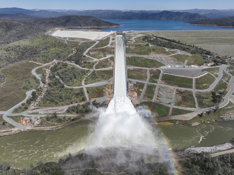
A drone provides an aerial view of a cloud mist formed as water flows over the four energy dissipater blocks at the end of the Lake Oroville Main Spillway. The California Department of Water Resources increased the water release down the main spillway to 35,000 cubic feet per second (cfs). Photo taken March 17, 2023.
Lake Oroville Water Releases Continue
The Department of Water Resources (DWR) continues to make releases from Lake Oroville using the main spillway at Oroville Dam. Ongoing releases ensure continued storage space in Lake Oroville for spring runoff from snowmelt and are closely coordinated with the U.S. Army Corps of Engineers and downstream water operators.
Total releases to the Feather River amount to 15,000 cubic feet per second (cfs) with 3,500 cfs being routed down the low-flow channel which flows through the City of Oroville. An additional 11,500 cfs is being released from the Thermalito Afterbay River Outlet, located 5 miles downstream from Oroville. DWR continues to closely monitor lake levels and will adjust releases accordingly.
Visitors to Oroville Dam may also notice minor amounts of water flowing from drains built into the emergency spillway. As the reservoir level has increased, water flow from the drains has increased, which is normal and expected with the emergency spillway design. The dam and emergency spillway continue to operate as intended.
Since Dec. 1, Lake Oroville’s storage has increased more than 210 feet and gained over 2 million acre-feet of water. The Lake Oroville reservoir is the largest storage facility in the State Water Project (SWP) and supports environmental and water delivery needs to 27 million Californians and reduces flood risks to downstream communities. DWR continues to monitor lake levels, weather forecasts, and mountain snow levels to optimize operations for water storage and environmental protection while allowing for carryover storage into next year.
Healthy Kids Day
Join the Oroville YMCA on Saturday, April 29 for a celebration of art in the community and Healthy Kids Day activities. Local Oroville schools and community groups will be showcasing performances in dance, theater, and music with visual arts and hands-on workshops. DWR’s Lake Oroville Visitor Center Guides will be promoting Healthy Kids Day activities with an information booth from 10 a.m. to 2 p.m. on how much water it takes to grow a healthy salad. A fun, hands-on activity will feature a coloring sheet that kids can cut out and glue together to create a healthy take-home salad! As we approach the summer recreation season, DWR will also be providing information on water safety for pools, rivers, and lakes. Stop by the Oroville Convention Center located at 1200 Myers Street from 10 a.m. to 5 p.m. to partake in a day of family-friendly activities.
Water Allocations Increased
DWR announced April 20 another increase in the forecasted State Water Project (SWP) deliveries this year. With reservoirs nearing capacity and snowmelt runoff starting to occur, DWR now expects to deliver 100 percent of requested water supplies, up from 75 percent announced in March. This water will be delivered throughout the year to the SWP’s 29 public water agencies that serve 27 million Californians and 750,000 acres of farmland. The last time the SWP allocated 100 percent was in 2006.
San Luis Reservoir in Merced County, which holds water supply for both the SWP and U.S. Bureau of Reclamation’s Central Valley Project (CVP), is now full. Additionally, Lake Oroville, the SWP’s largest reservoir, and SWP reservoirs in Southern California are expected to be full by the end of May. Statewide, reservoir storage is at 105 percent of average for this date.
“Water supply conditions and careful management of reservoir operations during this extreme winter allows DWR to maximize water deliveries while enhancing protections for the environment,” said DWR Director Karla Nemeth. “DWR is moving and storing as much water as possible to the benefit of communities, agriculture, and the environment.”
More information on SWP allocations may be found in the press release.
Oroville Recreation
DWR, State Parks, and CDFW maintain over 92 miles of trails in the Oroville area. Paved trails at the Lake Oroville Visitor Center, Spillway Day Use Area, and at the North Forebay Day Use Area offer accessible trails with only slight elevation changes. Other trails, such as the Brad Freeman Trail near Oroville Dam, offer steep elevation changes to challenge hikers and mountain bikers. The Saddle Dam Trailhead has facilities for equestrians, including a large parking area to accommodate horse trailers, water troughs, and hitching posts, and easy access to trails designated for hikers and horses.
An interactive map of recreation facilities, including open boat ramps, and their permitted uses (hike, bike, horse, multi) is available on DWR’s Lake Oroville Recreation webpage. A paper trail map is available at various locations, including most entrance kiosks and the Visitor Center.
Lake Oroville is one of the State Water Project’s premier recreational destinations and one of California’s best fishing spots. The lake provides both warm-water and cold-water fisheries. Below the Oroville Dam, the Thermalito Forebay, Thermalito Afterbay and the Feather River offer additional excellent fishing opportunities for Chinook salmon and steelhead. The marinas at Bidwell Canyon and Lime Saddle are open daily and provide a variety of services such as a shuttle and boat rentals.
Current Lake Operations
Lake Oroville is at 874 feet elevation and storage is approximately 3.15 million acre-feet (MAF), which is 89 percent of its total capacity and 119 percent of the historical average.
The Feather River releases are at 15,000 cubic feet per second (cfs). Flows through the City of Oroville are 3,500 cfs with 11,500 cfs released from the Thermalito Afterbay Outlet (Outlet) for a total of 15,000 cfs downstream of the Outlet. DWR continues to assess releases to the Feather River daily.
The public can track precipitation, snow, reservoir levels, and more at the California Data Exchange Center. The Lake Oroville gage station is identified as “ORO”.
All data as of midnight 4/20/2023.
