Lake Oroville Community Update - September 2, 2022.
Lime Saddle Marina showing Lake Oroville with a reservoir storage of 1,663,134 acre-feet (AF), 47 percent of the total capacity on July 6, 2022.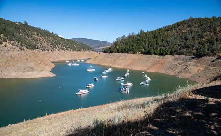
Boat Ramp Status
The boat ramp at the Lime Saddle recreation area closed Aug. 29 as lake elevations fell below safe launching levels. The Lime Saddle Marina will remain open and shuttle service to moored boats is available from 8:30 am. to 4 p.m. The Bidwell Canyon, Spillway, and Loafer Point boat ramps are open 24-hours/day, including over the Labor Day holiday weekend. The Bidwell Canyon Marina will be open from 8:30 am. to 8 p.m. with shuttle service available during that time.
The Monument Hill and Wilbur Road boat ramps on the Thermalito Afterbay are open and power and sail boating is permitted from 1.5 hours before sunrise to one hour after sunset. Please pay extra attention when boating in the Afterbay, as hundreds of baby Western and Clark’s Grebes have hatched in the Afterbay over the last two weeks as noted below. These new hatchlings do not yet have good mobility and are very vulnerable to boats at full speed, so please use caution. The Thermalito South Forebay is open to power and sail boating from 8 a.m. to sunset. The North Forebay off Highway 70 is open to non-motorized boating and is open 8 a.m. to sunset.
Boaters are reminded that a California Boater Card is required for all boat and personal watercraft (jet-ski) operators over 16 years of age. Operators 12 to 15 years of age can operate a boat or personal watercraft if immediately supervised by an adult over 18 in possession of a valid California Boater Card. Abiding by all safety requirements, including wearing life jackets and following speed restrictions, will ensure an enjoyable and safe recreation experience for all.
Oroville Recreation
The Lake Oroville area has over 92 miles of trails, open to hiking, with some also allowing for horseback riding, some also allowing biking, and some designated for “multi-use” where all three activities may occur on the same trail. The trails provide users with spectacular views of Lake Oroville and the valley, home to the Sutter Buttes – named the smallest mountain range in the world.
Trails and their permitted uses, day use areas, boat ramps and other recreation facilities are featured on DWR’s interactive map on DWR’s Lake Oroville Recreation webpage. Step inside the Lake Oroville Visitor Center, open Tuesday through Thursday from 9 a.m. to 5 p.m., to learn about the State Water Project and history of the area.
The Thermalito Forebay and Afterbay also provide a wide range of recreation opportunities including fishing, hiking, biking and boating. The North Forebay Aquatic Center has kayaks, paddle boards, and other watercraft available for rent. Non-motorized boating is also permitted in the Thermalito Diversion Pool with car-top boat launching access just before the restroom on Cherokee Road. Lake Oroville and the Oroville Wildlife Area also have car-top boat launch areas.
With a heat wave forecasted for the Labor Day weekend and beyond, everyone (and especially outdoor recreators) is reminded to stay hydrated, wear loose, light clothing and remember to pack plenty of sunscreen. Elderly persons and children are at higher risk for heat illness as well as the very serious condition of heat stroke. Visit the Center for Disease Control to learn how to detect these conditions.
View Chinook Salmon in the Feather River
Fall-run Chinook salmon are completing their life cycle and returning home to the Feather River to lay eggs for the next generation of salmon. Visitors to the Hatchery’s Fish Barrier Dam Overlook Viewing Area can watch salmon jumping and, after the fish ladder opens in mid-September, visitors can watch salmon swim up the ladder at the nearby Underwater Viewing window. The Overlook is located off Table Mountain Boulevard north of the Hatchery.
The Feather River Fish Hatchery plans to open the fish ladder the week of Sept. 12 to begin hatchery spawning operations which enables millions of Chinook salmon to be released to the river every spring. Visitors are also encouraged to visit the Hatchery (open daily 8 a.m. to 3 p.m.) and attend the 28th Annual Salmon Festival in Oroville on Sept. 24.
Grebes Nest Receive Help from DWR
Western and Clark’s grebes, with their distinctive red eyes, graceful necks, and long yellow bills, have returned to the Thermalito Afterbay for their nesting season. The shallow nature of the Afterbay is perfect for these two species of grebes who, along with only a few other aquatic bird species, build their nests on the water’s surface. Reservoirs like Thermalito Afterbay support more than 90 percent of the state’s breeding-grebe population, according to the Audubon Society.
DWR voluntarily restricts fluctuating the elevation of the Thermalito Afterbay for several weeks during the grebes nesting season because significant decreases in reservoir elevation could strand the nests out of the water or submerge them if elevations increase. Find more information about the grebes on the DWR Updates webpage. Photos can be found on DWR’s Pixel webpage – enter Grebes in the search bar after creating a free username and password to log in.
Blue Green Algae Monitoring
DWR environmental scientists regularly monitor Lake Oroville, the Thermalito North Forebay, and the Thermalito Afterbay for blue-green algae and their toxins, taking water samples from various locations regularly from Memorial Day through Labor Day. There are currently no harmful algal bloom (HAB) advisories for Lake Oroville, the Thermalito Forebay, or the Thermalito Afterbay.
If elevated levels of cyanobacteria toxins are found, DWR staff work with California’s Regional Water Quality Control Board and recreation area managers to notify the public and post advisory signs at affected waterbodies. To learn more about HABs, or to report a HAB, visit the Water Board’s website.
Blue-green algae (cyanobacteria) is a natural component of ecosystems. Under certain conditions, including warmer temperatures and increased nutrient loads, algae can grow rapidly causing “blooms.” Algal blooms sometimes produce toxins that can be harmful to people and animals.
Visit this comparison chart on the HABs website for additional information.
Fish Advisory for Antelope Lake
The California Office of Environmental Health Hazard Assessment (OEHHA) released an advisory for safe eating advice for black bass species, bullhead species, Golden Shiner, and sunfish species caught at Antelope Lake in Plumas County due to levels of mercury found in fish caught from the lake. The fish species tested at Antelope Lake had lower contaminant levels than is typical at many other California water bodies. All species tested at Antelope Lake can be eaten at least two times a week.
Mercury is released into the environment from mining and burning coal. It accumulates in fish in the form of methylmercury, which can damage the brain and nervous system, especially in developing children and fetuses. Because of this, OEHHA provides recommendations for safe eating that vary by age and gender. More information can be found in the OEHHA news release.
Current Lake Operations
The elevation of Oroville’s reservoir is about 707 feet elevation and storage is about 1.3 million acre-feet (MAF), which is 37 percent of its total capacity and 64 percent of historical average. An excessive heat warning is in effect beginning Saturday through Tuesday of next week. Daily highs during this period are forecasted to be just under 110 degrees. High temperatures are expected to continue later in the week in the low 100s and upper 90s.
The Feather River releases are currently at 3,000 cubic feet per second (cfs) to meet downstream Delta water quality and outflow needs. Flows through the City of Oroville are 800 cfs with 2,200 cfs released from the Thermalito Afterbay Outlet (Outlet) for a total of 3,000 cfs downstream of the Outlet. Flows through the low flow channel have been reduced for fisheries purposes.
The public can track precipitation, snow, reservoir levels, and more at the California Data Exchange Center at www.cdec.water.ca.gov. The Lake Oroville gage station is identified as “ORO”.
All data as of midnight 9/2/2022