Lake Oroville Community Update - March 25, 2022
Aerial view of Lake Oroville on March 17, 2022. 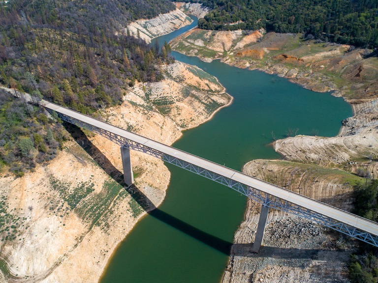
Oroville Dam Citizens Advisory Commission
The California Natural Resources Agency (CNRA) held its tenth Oroville Dam Citizens Advisory Commission meeting on March 25, 2022. The online public meeting included a facilities update from the Department of Water Resources (DWR), a presentation on addressing flood risks, and a discussion about public safety partnerships. Members of the public also offered comments and asked questions. The Citizens Advisory Commission is a forum to provide public feedback from the communities surrounding Oroville Dam. The meeting transcript and presentations will be available on the Commission’s website in the coming weeks at https://bit.ly/OrovilleCAC.
DWR Announces Revised Water Allocation
Last week, DWR announced it must reduce the State Water Project allocation to 5 percent of requested supplies for 2022. DWR previously set the allocation at 15 percent, but a historically dry January and February with no significant storms forecast for March requires a reduction in the allocation to conserve available water supply. In addition to the 5 percent allocation, DWR will also provide any unmet critical health and safety needs of the 29 water agencies that contract to receive State Water Project supplies.
“We are experiencing climate change whiplash in real time with extreme swings between wet and dry conditions. That means adjusting quickly based on the data and the science,” said DWR Director Karla Nemeth. “While we had hoped for more rain and snow, DWR has been preparing for a third consecutive year of drought since October. We are continuing with a series of actions to balance the needs of endangered species, water supply conservation, and water deliveries for millions of Californians.”
DWR will make its next assessment of the State Water Project allocation following the next snow survey on April 1. A final allocation for the water year is typically announced in May or June. Read the full news release on the DWR News webpage.
DWR Monitoring Vernal Pools
Some grasslands, including areas around Butte County, have an underlying impervious layer of rock or clay that causes rainwater to pond in the winter and spring, creating seasonal wetlands called vernal pools. Although vernal pools are only a small component of our local grasslands in terms of area, they support a remarkably high diversity of plants and animals, including rare and endangered species and species endemic to California (i.e., found nowhere else in the world).
Vernal pools often support spectacular wildflowers that bloom from March to May. Each spring, Department of Water Resources (DWR) environmental scientists from the Oroville Field Division monitor hundreds of vernal pools around the Oroville area and make assessments on how protection measures for these valuable environmental resources are succeeding.
This year scientists are observing wildflowers blooming earlier, likely due to drought conditions, which has reduced the number of “wet” vernal pools found. Scientists also noticed that the areas where CAL FIRE performed controlled burns around the Thermalito Forebay last year to remove invasive grass buildup, or ‘thatch’, and other invasive plants, are abundant with flowers – demonstrating the benefit of such activity on area grasslands and vernal pools.
Boat Ramp Closures
A speed boat timed trial event on the Thermalito Afterbay is scheduled for April 1 to April 3. The event requires that the southern portion of the Afterbay (south of Highway 162) to be closed to the public April 2 and April 3. Both the Monument Hill boat ramp and Larkin Cartop boat launch will be closed. The Wilbur Road boat ramp and areas north of Hwy 162 will remain open.
Returning to the Afterbay after two years away due to the COVID-19 pandemic, the 59th Annual Region 9 Bud David Time Trials event is anticipated to draw 40 to 50 boats. Information about the event can be found on the American Power Boat Association webpage at https://www.apba.org/racing-schedule.html
The Loafer Point boat launch area will be closed Monday, April 4 for installation of a gate. Boaters are encouraged to use the Bidwell Canyon boat ramp as an alternate launch site on that day.
Oroville Recreation
The Loafer Point, Bidwell Canyon, and Lime Saddle boat ramps are open (except on April 4 for Loafer Point). The Oroville Dam Spillway boat ramp remains closed for repairs. The Foreman Creek and Stringtown cartop boat ramps are also open. Information on current boat ramp status can be found on the California State Parks’ Lake Oroville State Recreation Area webpage. Scroll down to the link for “Current Launch Ramp Status”.
The Loafer Creek Recreation Area is now open for all activities except group camping.
The Lake Oroville Visitor Center is open to the public on Tuesdays, Wednesdays, and Thursdays from 9 a.m. to 5 p.m. Pick up the Lake Oroville Trails Map, which shows more than 91 miles of trails available to equestrians, bicyclists, and hikers, at Lake Oroville State Recreation Area (LOSRA) kiosks, the Oroville Area Chamber of Commerce, or the Feather River Recreation and Parks District.
Visit the California Parks LOSRA webpage for current information on facility status and campground reservations. An interactive map of recreation facilities in DWR’s Oroville-Thermalito Complex is available on DWR’s Lake Oroville Recreation webpage. Information about the 11,000-acre Oroville Wildlife Area is available on the California Department of Fish and Wildlife webpage.
Current Lake Operations
The elevation of Oroville’s reservoir is about 746 feet elevation and storage is about 1.64 million acre-feet, which is 47 percent of its total capacity and 67 percent of historical average. Temperatures over the weekend and next week are forecasted to be in the 70s with a chance of rain over the weekend.
The average daily inflows this week have been around 3,000 to 5,000 cubic feet per second (cfs) and projected to continue at this rate next week. Inflows are subject to change based upon on actual weather conditions.
Total flows to the Feather River are 2,500 cfs. Flow in the low-flow channel through the City of Oroville is 650 cfs and flow through the Thermalito Afterbay Outlet currently is 1,850 cfs. Flows are assessed daily.
The public can track precipitation, snow, reservoir levels, and more at the California Data Exchange Center at www.cdec.water.ca.gov. The Lake Oroville gage station is identified as “ORO”.
All data as of midnight 3/24/2022