Q/A: Going With the Flow: Modern Intake Design Goes Easy on the Fish
Image of fish screen.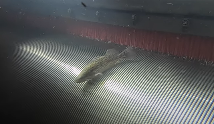
The Delta Conveyance Deep Dive video series has explored a wide range of topics including climate change, financing the project, tunnel construction and Delta fisheries, among others. We return to the subject of fish again, this time with an in-depth look at the design of water intakes and fish screens.
Preventing fish from getting caught up in the water diverted at the intakes - a situation known as “entrainment” - is a high priority and many innovative technologies have been developed to meet the challenge. We invited two of the project’s leading experts on intakes and fish screens, Phil Ryan and Darryl Hayes, to tell us about how the Delta Conveyance Project is addressing the challenges of intake design and siting for the project.
Phil Ryan is the engineering design manager and intakes lead for the Delta Conveyance Design and Constructional Authority (DCA). He has over 35 years of experience with planning and design of major conveyance facilities, including large river and lake intakes throughout the United States.
Darryl Hayes is a supervising engineer at DWR’s Delta’s conveyance office. He has a long history working for both DWR and in private practice on the planning, design and implementation of many fish facilities and river investigations in the Bay Delta, as well as in many parts of the United States.
DWR’s Kathryn Icelow hosted the interview.
KATHRYN ICELOW: Darryl, let’s start with the basics. Tell us about water supply intakes. What are they designed to do?
DARRYL HAYES: There are basically two functions of a water supply intake; it’s water supply as well as fish protection. So, for fish protection, we draw water through the screen at a very low velocity. We have a barrier that keeps the fish out and we accomplish this slow velocity by creating a large surface area in front of the pumps or the diversion facility. The intake screen mesh is sized conservatively with very fine slots to keep the fish out because at various times of the year, especially on the lower Sacramento River, there are a number of endangered fish species that may be impacted by these diversions. Those fish can include salmon, delta smelt and sturgeon - fish which are all currently listed as endangered or needing protection - so we design the facilities around those requirements.
KI: Thanks Darryl. Phil, could you tell us a bit more about that? What determines the size of an intake, and can you give us an idea of the scale that we are talking about for this particular project?
PHIL RYAN: Sure. For the Delta Conveyance Project intakes, we are proposing one or more intakes that are each going to be designed for a maximum diversion of between 1,500 and 3,000 cubic feet per second, or CFS, bringing that flow from the river. Distributing that maximum diversion flow at each intake over a minimum screen surface gives you an area for the larger ones of 3,000 CFS intakes of about 15,000 square feet. All that screen area has to be below the water surface so that you can achieve the desired 0.2 feet per second approach velocity that Darryl just mentioned. Most of these facilities that we design provide a slightly larger than necessary screen surface to be sure that a reasonably uniform velocity criteria can be achieved even with some degree of screen blockage. I thought it would be good in the beginning here to actually take a look at an example of a fish screen and I think Darryl has something that he can show us.
DARRYL HAYES: Yes, thanks Phil. Here I have a sample of a fish screen material. It’s a slotted material made out of a corrosion-resistant material like stainless steel. The slots are designed to physically exclude the fish, and here I have a model of a 2-inch-long fish. The screens themselves are designed for about 1-inch-long fish, and the idea is that they can’t physically pass through the screen and can swim away easily and continue to pass on by the screen.
KI: Thanks, Darryl. Now I know that a great amount of time and effort went into determining the best locations for the intakes. So, Phil, can you tell us about how the locations of the intakes have been selected for this project?
PR: Sure. There’s a lot of drivers associated with selecting the intake locations. They involve having enough depth to accommodate the screens. You’ve got to put the 15,000 square feet of screen under the water, and that can be quite long and require quite a bit of depth. So, you need that depth and you also need suitable straight lengths so you can put the screen along the banks without it getting into the river where it might impact flood flows. You are also looking at the outside of moderate river bends or along straight sections. You don’t ever want to be on the inside of a bend because the goal is to avoid areas where sediment will shoal or collect in those areas on the inside of bends.
Also, these intakes are more than just a river feature. They also have land-side features and you need suitable land-side topography and other features. You also need suitable geology because intakes are large structures, and they are built into the flood control levees along the river. So, there are all sorts of geologic and geotechnical considerations.
Considering all of these things, we looked at the Sacramento River between the confluence with the American River and downstream to the confluence with Sutter Slough. The flows from the American River entering the Sacramento River up in Sacramento gives the greatest sweeping velocity past the front of the structures so that fish can be swept past the structures as much as possible. Once you get down to Sutter Slough, the river starts to braid into channels and sloughs through the Delta as it flows down towards the Golden Gate. So that sets the area between the American River and Sutter Slough as the viable area for the intakes. All of these things as well as the entire river reach from Sacramento to Courtland were considered.
There are only five suitable candidate sites that exist along the river in these areas that meet all of these criteria. Two of those sites were eliminated due to characteristics that were less favorable than the other three sites. Of the final three sites, two of them were somewhat better. They were a little bit deeper, had better geology and less disruption on the land side.