Lake Oroville Community Update - January 21, 2022
Image of Lake Oroville in January 2022.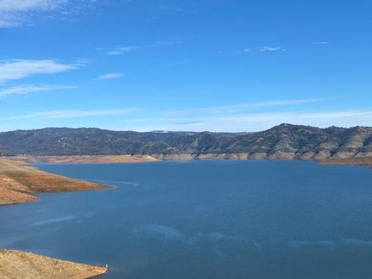
DWR Issues Revised Water Allocation
Due to the series of storms in December 2021, the Department of Water Resources (DWR) is increasing the State Water Project (SWP) allocation to 15 percent of requested supplies for 2022, an increase over the December allocation that covered only critical health and safety needs of the 29 water agencies that contract to receive State Water Project supplies.
While drought conditions still persist, December’s precipitation enabled DWR to convey and store water in San Luis Reservoir, allowing for the modest increase in water deliveries. DWR continues to plan for a third dry year by preserving storage in Lake Oroville, the State Water Project’s largest reservoir. Water releases from Lake Oroville will be prioritized to maintain Delta water quality, protect endangered species, and meet senior water right needs.
Each year, DWR makes an initial SWP allocation on Dec. 1. Allocations are updated as snowpack and runoff information are assessed, with a final allocation typically determined in May or June. Read the full news release on the DWR News webpage.
Drought Update
January’s dry weather reflects California’s weather variability -- not only from year to year but within the water year as well (Oct. 1 to Sept. 30). California has received more precipitation this water year as compared to this time last year but the abrupt change from December’s series of strong storms to a very dry January is a kind of “weather whiplash” that is becoming more common as climate change impacts continue to grow.
The remainder of the wet season is still ahead. California receives 75 percent of its precipitation from November through March, half of which is typically received between December through February. Currently the statewide snowpack is around 58 percent of seasonal average and about 113 percent of average for this date. California needs above average precipitation throughout the winter to offset record-setting drought conditions and replenish reservoirs. Currently, Lake Oroville is only filled to 44 percent of its capacity and major reservoirs across the state are at an average of 42 percent capacity.
Governor Newsom has called on Californians to voluntarily reduce their water use by 15 percent with simple measures to protect water reserves. The October 2021 emergency proclamation expanded the drought emergency statewide and authorized the State Water Board to ban wasteful water uses, boosting conservation efforts. Learn how to save for the future by visiting the Save Our Water website.
Mid-Winter Bald Eagle Survey
Environmental scientists from DWR participated in the National Midwinter Bald Eagle Survey on Jan. 7. This nation-wide effort, coordinated by the U.S. Army Corps of Engineers, aims to determine bald eagle distribution and identify areas of important winter habitats. Because of bad weather on the day of the national survey, this year’s official count at Lake Oroville was only 20 bald eagles; however, an informal survey two days later counted well over 100 migrating eagles at the lake.
Lake Oroville, the Feather River, and local area rice fields provide an ideal habitat for bald eagles. Fish are one of the eagle’s main food sources and water bodies like Lake Oroville, rivers, and rice fields provide a wide variety of fish and other favorite food sources such as waterfowl, small birds, and mammals. The many trees and snags (tall dead trees) near water areas provide prime roosting and hunting locations for the bald eagles that migrate to and through the area during the winter months as well as nesting opportunities for Lake Oroville’s resident “nesting pairs” who have established their home here.
Protecting the area’s year-round bald eagle population living in the DWR Oroville-Thermalito Complex jurisdiction is the responsibility of the DWR environmental scientists. The bald eagle is a protected species under the Migratory Bird Treaty Act of 1918 and Bald and Golden Eagle Protection Act of 1940. They were listed as an endangered species in 1978. Those protections have been successful, and the species is now federally delisted. DWR’s scientists monitor for and, if necessary, act against threats such as public intrusions, habitat loss, or other impacts to the eagles’ nesting areas.
Lakeside Access Road
Construction activities associated with the Lakeside Access Road project continue to result in intermittent closures of the Oroville Dam Crest parking lot on the northwest side of the dam. These short duration closures are anticipated to continue until the end of January. The popular walking/bicycling trail across the top of the dam will remain open and parking will continue to be available at the Upper Overlook.
This project will consist of a new, permanent, paved road from the west side of Oroville Dam to the Spillway Boat Ramp parking lot on the “lakeside,” or waterside, of the Oroville Dam spillways. This new road will allow a more direct route when water levels are low in Lake Oroville. The new road will include two concrete traffic lanes, wide shoulders for walking and biking, guardrails, and safety signage.
Loafer Creek Recreation Area
The Loafer Creek Recreation Area at Lake Oroville continues to be temporarily closed due to damages and interruption of the park’s main water supply system. Hikers, bicyclists, and equestrians can still access area trails from the Saddle Dam trailhead facility off Kelly Ridge Road. Trail users are advised to be aware of California Department of Parks and Recreation (State Parks) work trucks and utility vehicles in the area.
Oroville Recreation
Bidwell Canyon’s Stage II concrete boat ramp and the Lime Saddle Boat Ramp are open. The Spillway boat ramp remains closed for repair and the Loafer Point boat ramp is inaccessible due to continued closure of the Loafer Creek Recreation Area. The Foreman Creek and Stringtown cartop boat ramps have also reopened. Information on current boat ramp status can be found on the State Park’s Lake Oroville State Recreation Area webpage. Scroll down to the link for “Current Boat Ramp Status”.
The Lake Oroville Visitor Center is open to the public on Tuesdays, Wednesdays, and Thursdays from 9 a.m. to 5 p.m. Pick up the Lake Oroville Trails Map, which shows more than 97 miles of trails available to equestrians, bicyclists, and hikers, at Lake Oroville State Recreation Area (LOSRA) kiosks, the Oroville Area Chamber of Commerce, or the Feather River Recreation and Parks District.
Visit the California Parks LOSRA webpage for current information on facility status and campground reservations. An interactive map of recreation facilities in DWR’s Oroville-Thermalito Complex is available on DWR’s Lake Oroville Recreation webpage. Information about the 11,000-acre Oroville Wildlife Area is available on the California Department of Fish and Wildlife webpage.
Current Lake Operations
The elevation of Oroville’s reservoir is about 739 feet elevation and storage is about 1.58 million acre-feet, which is 45 percent of its total capacity and 80 percent of historical average. Dry and cool conditions are forecasted over the weekend and continuing into next week.
The average daily inflows this week have been in the range of 4,000 cubic feet per second (cfs) to 5,000 cfs. Inflows through the weekend and next week are forecasted to be in the range of 3,000 cfs to 5,000 cfs. Inflows are subject to change based upon on actual weather conditions.
Total flows to the Feather River are at 950 cfs for meeting downstream water quality and flow requirements. Flow in the low-flow channel, through the City of Oroville, is 650 cfs and flow through the Thermalito Afterbay Outlet is 300 cfs. Releases are assessed daily.
The public can track precipitation, snow, reservoir levels, and more at the California Data Exchange Center at www.cdec.water.ca.gov. The Lake Oroville gage station is identified as “ORO”.
All data as of midnight 1/20/2022