Lake Oroville Community Update - January 14, 2022
Image of Hyatt Pumping Plant. 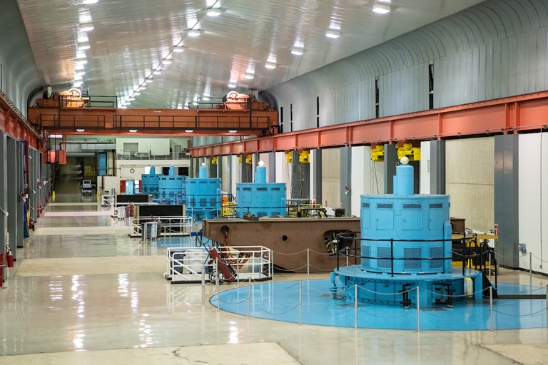
Mid-Winter Bald Eagle Survey
Environmental scientists from the Department of Water Resources (DWR) recently participated in the National Midwinter Bald Eagle Survey on Jan. 7. This nation-wide effort, coordinated by the U.S. Army Corps of Engineers, aims to determine bald eagle distribution and identify areas of important winter habitats. Because of bad weather on the day of the national survey, this year’s official count was only 20 bald eagles; however, an informal survey two days later counted well over 100 migrating eagles.
Lake Oroville and the Feather River area provide an ideal habitat for bald eagles. Fish are one of the eagle’s main food sources and large water bodies like Lake Oroville provide a wide variety of fish and other favorite food sources such as waterfowl, small birds, and mammals. The many trees and snags (tall dead trees) near water areas provide prime roosting and hunting locations for the bald eagles that migrate to and through the area during the winter months as well as nesting opportunities for Lake Oroville’s resident “nesting pairs” who have established their home here.
Protecting the area’s year-round bald eagle population living in the DWR Oroville-Thermalito Complex jurisdiction is the responsibility of the Oroville Field Division’s environmental scientists. The bald eagle is a protected species under the Migratory Bird Treaty Act of 1918 and Bald and Golden Eagle Protection Act of 1940. They were listed as an endangered species in 1978. Those protections have been successful, and the species is now federally delisted. DWR’s scientists monitor for and, if necessary, act against threats such as public intrusions, habitat loss, or other impacts to the eagles’ nesting areas.
Hyatt Powerplant Returns to Service
Oroville Dam’s Hyatt Powerplant returned to service on Jan. 1, 2022 after going offline on Aug. 5, 2021 due to historic low lake levels driven by California’s ongoing severe drought conditions. An unexpectedly strong atmospheric river storm in late October, followed by a series of powerful December storms, has increased reservoir elevation levels from 630 feet on Oct. 21, 2021 to nearly 733 on Jan. 14, 2022 – a gain of over 100 feet. Water levels are now well above the powerplant’s intakes, providing the necessary water pressure for efficient operation of the plant.
Currently, Hyatt powerplant is utilizing one generating unit to produce electricity and supply it to the state’s electrical grid managed by the California Independent System Operator. Hyatt generation will initially remain low due to low agricultural demands and improved delta salinity conditions. DWR anticipates an average outflow of about 900 cubic feet per second, which will generate approximately 30 megawatts of power. As lake levels rise and demands increase, additional units will be brought back online.
DWR completed major maintenance activities while the powerplant was offline to ensure the plant maintains its reliability and is available for water deliveries and power generation. DWR continues to manage Lake Oroville to balance storage needs with requirements for Delta outflows, water quality, and public health and safety requirements in an effort to conserve as much storage as possible in the event of another dry year. Read the news release at DWR News Releases.
25th Anniversary of 1997 Floods
At the start of the new year in 1997, an atmospheric river from the warm waters near Hawaii, what used to be called a “pineapple express”, drenched the Sierra foothills – up to 40 inches of precipitation over the course of the storm in some locations. Multiple rivers and flood channels overflowed, and areas up and down California’s Central Valley experienced breached levees, flooded farmland, and inundated towns and highways. The result was over $2 billion in damage and three lives lost.
In the years since, DWR, through key improvements in forecasting, resources, levee infrastructure, and reconnected floodplain, has worked tirelessly with multiple partners to improve California’s ability to predict, prepare for, and respond to atmospheric river storms that often cause such damaging flood events. Read more about these efforts and find links to this year’s coverage of the anniversary on the DWR Updates webpage.
Drought Update
The current dry weather, forecasted to continue for several weeks, reflects California’s weather variability -- not only from year to year but within the water year as well (Oct. 1 to Sept. 30). The record-setting late October atmospheric river storm turned into a dry November followed by the series of strong storms in December that have transitioned to a dry start in January – a kind of “weather whiplash” that is becoming more common as climate change impacts continue to grow.
On average, California receives 75 percent of its precipitation from November through March, half of which is typically received between December through February. Currently the statewide snowpack is around 58 percent of seasonal average and about 126 percent of average for this date. California needs above average precipitation throughout the winter to offset the record-setting drought conditions. Currently, Lake Oroville is only filled to 43 percent of its capacity and major reservoirs across the state are at an average of 41 percent capacity.
While there may be more dry days than wet, large atmospheric rivers can still occur, depositing substantial precipitation in a short period as we saw in October 2021. This raises the risk of flood events, especially in burn scar areas. Find information about how to be prepared for floods on the DWR Flood Preparedness webpage.
Lakeside Access Road
Construction activities associated with the Lakeside Access Road project will result in intermittent closures of the Oroville Dam Crest parking lot on the northwest side of the dam. These short duration closures are anticipated to continue until the end of January. The popular walking/bicycling trail across the top of the dam will remain open and parking will continue to be available at the Upper Overlook.
This project will consist of a new, permanent, paved road from the west side of Oroville Dam to the Spillway Boat Ramp parking lot on the “lakeside,” or waterside, of the Oroville Dam spillways. This new road will allow a more direct route when water levels are low in Lake Oroville. The new road will include two concrete traffic lanes, wide shoulders for walking and biking, guardrails, and safety signage.
Loafer Creek Recreation Area
The Loafer Creek Recreation Area at Lake Oroville continues to be temporarily closed due to damages and interruption of the park’s main water supply system. Hikers, bicyclists, and equestrians can still access area trails from the Saddle Dam trailhead facility off Kelly Ridge Road. Trail users are advised to be aware of California Department of Parks and Recreation (State Parks) work trucks and utility vehicles in the area.
Oroville Recreation
Bidwell Canyon’s Stage II concrete boat ramp and the Lime Saddle Boat Ramp are open. The Spillway boat ramp remains closed for repair and the Loafer Point boat ramp is inaccessible due to continued closure of the Loafer Creek Recreation Area. The Foreman Creek and Stringtown cartop boat ramps have also reopened. Information on current boat ramp status can be found on the State Park’s Lake Oroville State Recreation Area webpage. Scroll down to the link for “Current Boat Ramp Status”.
The Lake Oroville Visitor Center is open to the public on Tuesdays, Wednesdays, and Thursdays from 9 a.m. to 5 p.m. Pick up the Lake Oroville Trails Map, which shows more than 97 miles of trails available to equestrians, bicyclists, and hikers, at Lake Oroville State Recreation Area (LOSRA) kiosks, the Oroville Area Chamber of Commerce, or the Feather River Recreation and Parks District.
Visit the California Parks LOSRA webpage for current information on facility status and campground reservations. An interactive map of recreation facilities in DWR’s Oroville-Thermalito Complex is available on DWR’s Lake Oroville Recreation webpage. Information about the 11,000-acre Oroville Wildlife Area is available on the California Department of Fish and Wildlife webpage.
Current Lake Operations
The elevation of Oroville’s reservoir is about 733 feet elevation and storage is about 1.51 million acre-feet, which is 43 percent of its total capacity and 79 percent of historical average. Dry and cool conditions over the weekend and continuing into next week.
The average daily inflows this week have been in the range of 6,000 cfs to 8,000 cubic feet per second (cfs) and have been tapering off with the dry conditions. Inflows through the weekend and next week are forecasted to be in the range of 3,000 cfs to 5,000 cfs. Inflows are subject to change based upon on actual weather conditions.
Total flows to the Feather River are at 950 cfs for meeting downstream water quality and flow requirements. Flow in the low-flow channel, through the City of Oroville, is 650 cfs and flow through the Thermalito Afterbay Outlet is 300 cfs. Releases are assessed daily.
The public can track precipitation, snow, reservoir levels, and more at the California Data Exchange Center at www.cdec.water.ca.gov. The Lake Oroville gage station is identified as “ORO”.
All data as of midnight 1/12/2022