Lake Oroville Community Update - February 4, 2022
Aerial view of Lake Oroville on January 25, 2022. 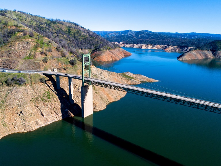
Snow Survey
The Department of Water Resources (DWR) conducted its second snow survey of the season at Phillips Station. Following a dry January, the manual survey recorded 48.5 inches of snow depth and a snow water equivalent of 19 inches, which is 109 percent of average for this location Feb. 1.
The snow water equivalent measures the amount of water contained in the snowpack and is a key component of DWR’s water supply forecast. Statewide, the snowpack is 92 percent of average for Feb. 1.
For the northern Sierra, including the Feather River watershed, the average snow water equivalent measured 16.7 inches -- 58 percent of April 1 average and 86 percent of normal for Feb. 1.
“We are definitely still in a drought. A completely dry January shows how quickly surpluses can disappear,” said DWR Director Karla Nemeth. “The variability of California weather proves that nothing is guaranteed and further emphasizes the need to conserve and continue preparing for a possible third dry year.” The full news release can be read on the DWR News webpage.
Christmas Tree Fish Habitat
The successful partnership to support fish habitat continues again this year. DWR, the California Department of Fish and Wildlife (CDFW) and the California Conservation Corps (CCC) have started constructing fish habitat structures at Lake Oroville and the Thermalito Afterbay using over 1,100 recycled Christmas trees. The trees were again collected by Chico Boy Scout Troop 2 and delivered free of charge to DWR by Recology, a local waste management company.
To create the habitat on Lake Oroville and the Thermalito Afterbay, members of the CCC team bundle the recycled holiday trees together and anchor them in various locations around the lakebed. Anchoring the trees allows them to remain submerged providing juvenile fish safe refuge, improving fisheries and recreational fishing opportunities.
For nearly 30 years, DWR has worked with local groups to construct fish habitat structures, which is one of the longest continuously running fish habitat improvement programs in the State of California. The 2022 project is anticipated to be completed by Feb. 9.
Oroville Recreation Advisory Committee
The Oroville Recreation Advisory Committee held a virtual meeting on Friday, Feb. 4. ORAC was established by the Federal Energy Regulatory Commission (FERC) to review and provide recommendations regarding DWR’s recreation plan for the Project No. 2100 – Oroville Facilities. The 13-member committee is made up of representatives from state and local government, sports and recreation groups, and business and community organizations. To obtain a summary of the meeting, send a request to oroville@water.ca.gov.
Loafer Point Boat Ramp
The Loafer Point Stage II boat ramp has reopened for boat launching. The first construction phase of the new boat ramp was completed in May 2021, adding six boat launch lanes to 707 feet, 180 trailered parking spaces, and offering immediate access to the open waters of Lake Oroville. Falling lake levels due to drought conditions forced its closure a month later in June 2021.
Taking advantage of historic low lake elevations, construction to extend three of the six boat launch lanes further into the lakebed to improve low-water access to Lake Oroville began the first week of October. The project was successfully completed to 675 feet before rising lake elevations prevented further work. With lake elevations currently at 744 feet, all six lanes of the Stage II boat ramp are currently available.
The Loafer Point Stage I boat ramp was completed in 2020 and added three new boat launch lanes from a full lake down to 805 feet, a new parking area, and a restroom facility. Both boat ramps are adjacent to the Loafer Creek Recreation Day Use Area and Campground, rounding out a full-service recreation destination with nearby trails, campgrounds, boating, and marina. Except the Loafer Point Stage II boat ramp and the trails network, the remainder of the Loafer Creek Recreation Area is currently closed due to waterline repair. Trails within the Loafer Creek Recreation Area can be accessed from the Bidwell Saddle Dam Trailhead located on Kelly Ridge Road.
Lakeside Access Road
Construction activities associated with the Lakeside Access Road project continue to result in intermittent closures of the Oroville Dam Crest parking lot on the northwest side of the dam as well as the Spillway Boat Ramp area. These short duration closures are anticipated to continue until the end of February. The popular walking/bicycling trail across the top of the dam will remain open and parking will continue to be available at the Upper Overlook.
This project will consist of a new, permanent, paved road from the west side of Oroville Dam to the Spillway Boat Ramp parking lot on the “lakeside,” or waterside, of the Oroville Dam spillways. This new road will allow a more direct route when water levels are low in Lake Oroville. The new road will include two concrete traffic lanes, wide shoulders for walking and biking, guardrails, and safety signage.
Oroville Recreation
The Loafer Point, Bidwell Canyon, and Lime Saddle Boat Ramps are open. The Spillway boat ramp remains closed for repairs. The Foreman Creek and Stringtown cartop boat ramps are also open. Information on current boat ramp status can be found on the State Park’s Lake Oroville State Recreation Area webpage. Scroll down to the link for “Current Boat Ramp Status”.
The Lake Oroville Visitor Center is open to the public on Tuesdays, Wednesdays, and Thursdays from 9 a.m. to 5 p.m. Pick up the Lake Oroville Trails Map, which shows more than 97 miles of trails available to equestrians, bicyclists, and hikers, at Lake Oroville State Recreation Area (LOSRA) kiosks, the Oroville Area Chamber of Commerce, or the Feather River Recreation and Parks District. The Loafer Creek Recreation Area continues to be closed due to waterline repair (boat ramp access allowed).
Visit the California Parks LOSRA webpage for current information on facility status and campground reservations. An interactive map of recreation facilities in DWR’s Oroville-Thermalito Complex is available on DWR’s Lake Oroville Recreation webpage. Information about the 11,000-acre Oroville Wildlife Area is available on the California Department of Fish and Wildlife webpage.
Current Lake Operations
The elevation of Oroville’s reservoir is about 746 feet elevation and storage is about 1.64 million acre-feet, which is 46 percent of its total capacity and 79 percent of historical average. The forecast calls for dry and primarily sunny conditions with temperatures in the high 60s to high 70s during the day and dropping to the upper 30s to low 40s at night.
The average daily inflows this week have been in the range of 3,000 cubic feet per second (cfs) to 4,000 cfs. Inflows through the weekend and next week are forecasted to be around 3,000 cfs. Inflows are subject to change based upon on actual weather conditions.
Total flows to the Feather River are 3,250 cfs. This increase is for downstream water quality and flow requirements. Flow in the low-flow channel through the City of Oroville is 650 cfs and flow through the Thermalito Afterbay Outlet is 2,600 cfs. Releases are assessed daily.
The public can track precipitation, snow, reservoir levels, and more at the California Data Exchange Center at www.cdec.water.ca.gov. The Lake Oroville gage station is identified as “ORO”.
All data as of midnight 2/3/2022