Lake Oroville Community Update - June 4, 2021
An aerial drone view showing Bidwell Canyon Marina on Lake Oroville on May 4, 2021.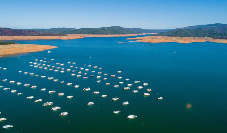
Lake Oroville Boat Ramp Status
The Lime Saddle and Loafer Point boat ramps closed June 3. Although water may still cover the bottom of the boat ramp, there is not enough depth over the paved ramp to safely launch and trailer boats. Both the Lime Saddle and Bidwell Canyon marinas will remain open from 8 a.m. until sundown.
The remaining boat ramps at the Spillway and Bidwell Canyon are currently open with future status dependent on lake levels. Boat ramp information can be obtained by calling the CA Department of Parks and Recreation (CA Parks) at 530-538-2200 or visiting the Lake Oroville State Recreation Area (LOSRA) website at www.parks.ca.gov/LakeOroville.
Oroville Recreation
More than 97 miles of trails and numerous Day Use Area (DUA) facilities with picnic tables and restrooms at Lake Oroville State Recreation Area (LOSRA) are open 8 a.m. to sunset. Bidwell, Lime Saddle, and Loafer Creek Recreation Areas are open 24 hours. Summer access hours of 5 a.m. to 11 p.m. daily is now in effect for the Spillway Boat Ramp Area - gates close at 11 p.m. Vehicle access to Oroville Dam Crest Road across Oroville Dam is available 5 a.m. to 11 p.m. daily.
Exercise enthusiasts can log a round-trip of just over two miles while they enjoy the spectacular views from Oroville Dam Crest Road across the top of the dam, which is open to walkers, joggers, and bicyclists 24-hours a day. Surrounded by trails, the Thermalito Diversion Pool is open for kayaking and other non-motorized boating.
Visitors to the Thermalito North Forebay will find a full CA Parks facility with restrooms, picnic areas, a swim beach, and the Forebay Aquatic Center with kayaks, paddle boards, and other watercraft available for rent. The Monument Hill facility at the Thermalito Afterbay also provides boat ramp access, restrooms, picnic area, and a swim beach. The Feather River Fish Hatchery’s viewing area and fish ladder are open to the public. The Lake Oroville Visitor Center remains closed due to COVID-19 restrictions.
Visit the California Parks LOSRA webpage for current information on facility status, campground reservations, and to find current requirements to protect public health during the COVID-19 pandemic. An interactive map of recreation facilities in DWR’s Oroville-Thermalito Complex is available on DWR’s Lake Oroville Recreation webpage. Information about the 11,000-acre Oroville Wildlife Area is available on the California Department of Fish and Wildlife webpage.
Thermalito Forebay Control Burn Successful
A series of vegetation management burns around the Thermalito Forebay was conducted by CAL FIRE/Butte County Fire Department on June 3 in cooperation with the Department of Water Resources (DWR) and CA Parks. A total of about 245 acres near the Forebay Aquatic Center (~20 acres), Nelson Sports Complex (~40 acres), South Forebay near Grand Avenue (~65 acres), and near Wilbur Road and Tres Vias Road (~120 acres) was successfully treated.
The vegetation management-controlled burns have multiple beneficial impacts for the natural environment and public safety. The grasslands around the Thermalito Forebay are home to many seasonal wetlands called vernal pools. Although vernal pools are only a small component of these grasslands, they support a high diversity of California native plants and animals, including rare and endangered species and species endemic to California (i.e., found nowhere else in the world).
Fire from carefully controlled burns is the most powerful tool to combat invasive plants and dry invasive grass buildup called ‘thatch’ within these grasslands and vernal pools. Removal of invasive species allows native plants and animal species, such as fairy shrimp, to thrive. The burns will also remove dangerous fire fuels from grassland adjacent to private property and near high-use areas.
Blue Green Algae Monitoring
DWR environmental scientists regularly monitor for blue-green algae and their toxins during the summer months. There are currently no HAB advisories for Lake Oroville, Upper Feather River lakes, the Thermalito Forebay, or the Thermalito Afterbay. Water samples are taken at various locations regularly from Memorial Day through Labor Day and sent to a lab for toxin analysis.
Blue-green algae (cyanobacteria) is a natural component of ecosystems. Under certain conditions, including warmer temperatures and increased nutrient loads, algae can grow rapidly causing “blooms.” Algal blooms sometimes produce toxins that can be harmful to people and animals. Algal blooms can make the water appear green, blue, or brown in color. Seeing colors, mats, foam, scum, or paint-like streaks in the water may indicate a bloom is present. Keep animals and children away from the water when a suspected harmful algal bloom (HAB) is present and report the possible HAB immediately.
If elevated levels of cyanobacteria toxins are found while testing, DWR staff will work with California’s Regional Water Quality Control Board and recreation area managers to notify the public and post advisory signs at affected waterbodies. To learn more about HABs, or to report a HAB visit the Water Board’s website.
Current Lake Operations
The elevation of Oroville’s reservoir is about 709 feet elevation and storage is about 1.32 million acre-feet -- 38 percent full and 45 percent of historical average. Currently, in the Northern Sierra Basin, snowpack is also below average at five percent of normal. Temperatures are forecast to be in the mid- to high-90s over the weekend, with the temperature expected be in the 80s for the rest of the week.
Currently, flows down the low flow channel through the City of Oroville are at 950 cfs and 1,100 cfs is being released from the Thermalito Afterbay Outlet (Outlet) for a total of 2,050 cfs downstream of the Outlet. Current releases are for meeting downstream water quality and flow requirements and are re-assessed on a daily basis. Flows may fluctuate through the low flow channel for fisheries purposes during the week.
The public can track precipitation, snow, reservoir levels, and more at the California Data Exchange Center at www.cdec.water.ca.gov. Lake Oroville is identified as “ORO”.
All data as of midnight 6/3/2021