Lake Oroville Community Update - July 23, 2021
An aerial drone view at Bidwell Bar Bridge showing Lake Oroville on July 20, 2021. 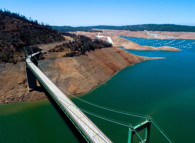
Drought Information
California is no stranger to drought; it is a recurring feature of our climate. Lake Oroville’s low lake levels are a reminder of this cycle of dry and wet years. This year’s drought conditions are being felt across the western United States, with many areas, including California’s Central Valley, identified as being in “extreme drought” - the highest category of drought conditions.
DWR has created a “Drought” webpage where definitions, historical trends, current information, and maps of California’s water systems can be found. Links to resources, DWR activities, research, and data are available. Read about how heatwaves are impacting drought conditions on the DWR Updates webpage.
The State of California recently launched a website drought.ca.gov. This website will serve as the State’s primary location for public drought news and information.
DWR is encouraging water conservation efforts by all Californians. Find out ways you can help by visiting the “Save Our Water” website.
New Bald Eagles at Lake Oroville
Environmental scientists with the Department of Water Resources (DWR) report they have observed four of the seven bald eagle pairs around Lake Oroville successfully raise seven eaglets this spring. The young eagles have fledged – grown flight feathers and become strong enough to attempt flight – and have been observed taking practice flights around their nests.
Lake Oroville and the Feather River area provide ideal habitat for bald eagles. Fish are one of the eagle’s main food sources and large water bodies like Lake Oroville provide a wide variety of fish as well as other favorite food sources such as waterfowl, small birds, and mammals. The many trees and snags (tall dead trees) near water areas provide prime nesting, roosting and hunting locations for the nesting pairs as well as other bald eagles that migrate to and through the area during the winter months.
Protecting the area’s year-round bald eagle population living in the Department’s Oroville-Thermalito Complex is the responsibility of the Oroville Field Division’s environmental scientists. The bald eagle is a protected species under the Migratory Bird Treaty Act of 1918 and Bald and Golden Eagle Protection Act of 1940, as well as being listed as a ‘threatened’ species by Congress. DWR’s scientists monitor for and mitigate against threats such as public intrusions, habitat loss, or other impacts to the eagle’s nesting areas. The area has both resident bald eagles as well as eagles who migrate through each year.
Boating at Oroville
All paved boat ramps on Lake Oroville are now closed due to low lake levels. A single-lane, gravel ramp adjacent to the Bidwell Canyon Stage III ramp is available for boat launching with parking only on the concrete Stage III or Stage II parking lots. Closure of this access may occur at any time as low lake levels and undeveloped site conditions could prevent safe launching of vessels. 4WD vehicles are highly recommended – please use at your own risk. Boat launching and vehicle traffic outside of the gravel path, designated by the traffic cones, is prohibited and may result in immediate closure of the facility.
Additionally, the gravel, single-lane boat ramp at the Spillway is open daily from 5 a.m. to 11 p.m. – gates to (and from) the Spillway Boat Ramp area close at 11 p.m.
Both of these auxiliary ramps are gravel on dirt which becomes slippery when wet, especially during times of heavy usage. To maintain the integrity of the ramp, drivers are encouraged to avoid tire spin by engaging vehicles in 4-wheel drive and accelerating slowly when exiting the ramp, with or without a loaded trailer.
Both the Lime Saddle and Bidwell Canyon marinas remain open from 8 a.m. until sundown with shuttle service and boat rentals available.
Power boats are allowed on the Thermalito South Forebay as well as the Thermalito Afterbay. A 5-miles per hour speed limit for all boats is enforced on the Afterbay north of the Highway 162 bridge and near the brood ponds on the east side of the reservoir. No motorized boating is allowed in the Thermalito North Forebay.
The Monument Hill facility at Thermalito Afterbay provides boat ramp access, restrooms, a picnic area, and a swim beach. The Thermalito South Forebay facility has a two-lane boat ramp, parking, restroom, picnic tables, BBQs, shade trees, and a fish cleaning station.
Oroville Recreation
Visitors to the Thermalito North Forebay will find a full CA Parks facility with restrooms, picnic areas, a swim beach, and the Forebay Aquatic Center with kayaks, paddle boards, and other watercraft available for rent.
Numerous Day Use Area (DUA) facilities with picnic tables and restrooms at Lake Oroville State Recreation Area (LOSRA) are open 8 a.m. to sunset. Bidwell, Lime Saddle, and Loafer Creek Recreation Areas are open 24 hours. The Oroville Dam Crest Road across Oroville Dam is available 5 a.m. to 11 p.m. daily and open to pedestrians and bicyclists 24-hours a day. The Lake Oroville Visitor Center anticipates re-opening later this summer.
Visit the California Parks LOSRA webpage for current information on facility status and campground reservations. An interactive map of recreation facilities in DWR’s Oroville-Thermalito Complex is available on DWR’s Lake Oroville Recreation webpage. Information about the 11,000-acre Oroville Wildlife Area is available on the California Department of Fish and Wildlife webpage.
Trails Map
A map of the trails maintained by DWR, CA Parks, and CDFW is now available at many Oroville locations including LOSRA kiosks, Oroville Wildlife Area office on Oro Dam Boulevard West, the Oroville Area Chamber of Commerce, and Feather River Recreation and Parks District.
The map, which folds to pocket size, provides information on permitted trail uses, elevation changes, trail length, and locations of more than 97 miles of trails around Lake Oroville, along the Feather River, Thermalito Forebays and Afterbay, and the Oroville Wildlife Area. Equestrians, bicyclists, and hikers are encouraged to take advantage of this new resource.
Grebes Nest Receive Help from DWR
Western and Clark’s grebes, with their distinctive red eyes, graceful necks and long yellow bills, have returned to the Thermalito Afterbay for their nesting season. The shallow nature of the Afterbay is perfect for these two species of grebes who, along with only a few other aquatic bird species, actually nest on the water.
DWR voluntarily restricts the elevation of the Thermalito Afterbay because significant decreases in reservoir elevation could strand the nests out of the water or submerge them if elevations increase.
Find more information about the grebes at the DWR Updates webpage. Photos can be found on DWR’s Pixel webpage – enter Grebes in the search bar after creating a user name and password to log in.
Blue Green Algae Monitoring
DWR environmental scientists regularly monitor for blue-green algae and their toxins during the summer months. There are currently no harmful algal bloom (HAB) advisories for Lake Oroville, the Thermalito Forebay, or the Thermalito Afterbay.
Water samples are taken at various locations regularly from Memorial Day through Labor Day and sent to a lab for toxin analysis. If elevated levels of cyanobacteria toxins are found while testing, DWR staff will work with California’s Regional Water Quality Control Board and recreation area managers to notify the public and post advisory signs at affected waterbodies. To learn more about HABs, or to report a HAB visit the Water Board’s website.
Current Lake Operations
The elevation of Oroville’s reservoir is about 655 feet elevation and storage is about 944,000 acre-feet which is 27 percent of its total capacity and 35 percent of historical average. Currently, in the Northern Sierra Basin, snowpack is also below average at five percent of normal. Warm temperatures ranging from the high-90s to the mid-100s are forecasted this weekend through next week.
Total flow to the Feather River is currently at 2,750 cubic feet per second (cfs) for meeting downstream water quality and flow requirements. Flow in the low flow channel, through the City of Oroville, is 2,650 cfs and flow through the Thermalito Afterbay Outlet is 100 cfs. Total releases to the Feather River are assessed daily. Flows through the City of Oroville through the low flow channel may fluctuate throughout the week for fisheries purposes.
The public can track precipitation, snow, reservoir levels, and more at the California Data Exchange Center at www.cdec.water.ca.gov. Lake Oroville is identified as “ORO”.
All data as of midnight 7/22/2021