Lake Oroville Community Update - August 13, 2021
Lake Oroville at an elevation of 650.65 feet, 26 percent of total capacity July 26, 2021. 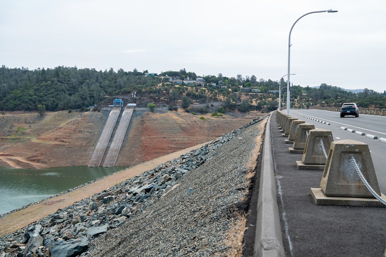
Cold Water Temperatures
Current releases to the Feather River from Oroville Dam’s River Valve Outlet System (RVOS), which draws water from the deepest part of Lake Oroville, has resulted in cold water temperatures in the Feather River and the Thermalito Diversion Pool, Forebay, and Afterbay. Water temperatures are ranging between 48 and 58 degrees.
Persons recreating on the Feather River and other waterbodies this summer are advised to wear life jackets. Entering cold water on hot summer days, called ‘cold water shock’, can cause breathing difficulties as well as changes in heart rate and blood pressure. Unplanned immersion, such as from a boat, kayak, or raft, or from jumping into the water from a beach, can be life-threatening, especially without a life jacket to help you stay afloat. Find cold-water safety tips at the National Weather Service’s Safety webpage.
Oroville Dam Citizens Advisory Commission Public Meeting
The California Natural Resources Agency is hosting its eighth Oroville Dam Citizens Advisory Commission meeting on August 27, 2021, from 10:00 a.m. to 12:00 p.m. The public meeting will be held online and will include presentations and public comment. The Commission will receive an overview of major projects and maintenance plans at the Oroville Dam facilities and will hear from a representative from the State Water Contractors. The Citizens Advisory Commission is a forum to provide public feedback from the communities surrounding Oroville Dam. For information on how to join the virtual meeting, visit https://bit.ly/OrovilleCAC.
Lake Oroville Historic Water Levels
Climate change-induced warm temperatures and extremely dry soils reduced expected runoff into rivers and reservoirs this spring. Combined with the past two years being the driest two-year period since 1976-1977, water levels at Lake Oroville reached historic lows in early August 2021, falling below the previous low water elevation of 645 feet set in September 1977.The Lake Oroville Storage Forecast Chart can be found on the State Water Project Operations and Maintenance website.
Hyatt Powerplant
On August 5, DWR State Water Project operations managers took the Hyatt Powerplant at Lake Oroville offline due to falling lake levels. This is the first time Hyatt Powerplant has gone offline as a result of low lake levels. However, DWR anticipated this moment, and the state has planned for its loss in both water and grid management.
DWR has been in regular communication about the status of Hyatt Powerplant with the California Independent Service Operator (CAISO) and the California Energy Commission and steps have been taken in anticipation of the loss of power generation.
DWR will continue to focus on reservoir operations and water storage management at Lake Oroville to preserve as much water in storage as possible. DWR will use the River Valve Outlet System to release some water from the base of Oroville Dam to maintain river temperature requirements and outflows to the Feather River.
Boating at Oroville
Launching of trailered boats at Lake Oroville’s temporary single-lane boat ramp at the Spillway closed August 6 due to unsafe conditions. Hand launching of small boats such as canoes or kayaks is permitted. As lake levels drop, the condition of the ramp will continue to be reassessed for future use. Both the Lime Saddle and Bidwell Canyon marinas remain open from 8 a.m. until sundown with shuttle service and boat rentals available.
State Parks has issued an order for the Lake Oroville State Recreation Area (LOSRA) that boating access on Lake Oroville is not permitted starting one-half hour after sunset and ending one-half hour before sunrise due to navigational hazards. Houseboats and vessels remaining on the water must be on their mooring ball or in a slip during hours of lake closure. Additional information can be obtained by calling State Parks at (530) 538-2200.
Power boats are allowed on the Thermalito South Forebay as well as the Thermalito Afterbay. A 5-miles per hour speed limit for all boats is in force on the Afterbay north of the Highway 162 bridge and near the brood ponds on the east side of the reservoir. No motorized boating is allowed in the Thermalito North Forebay.
The Monument Hill facility at Thermalito Afterbay provides boat ramp access, restrooms, a picnic area, and a swim beach. The Thermalito South Forebay facility has a two-lane boat ramp, parking, restroom, picnic tables, BBQs, shade trees, and a fish cleaning station.
Oroville Recreation
Visitors to the Thermalito North Forebay will find a full CA Parks facility with restrooms, picnic areas, a swim beach, and the Forebay Aquatic Center with kayaks, paddle boards, and other watercraft available for rent.
Numerous Day Use Area (DUA) facilities with picnic tables and restrooms at Lake Oroville State Recreation Area (LOSRA) are open 8 a.m. to sunset. Bidwell, Lime Saddle, and Loafer Creek Recreation Areas are open 24 hours. The Oroville Dam Crest Road across Oroville Dam is available 5 a.m. to 11 p.m. daily and open to pedestrians and bicyclists 24-hours a day. The Lake Oroville Visitor Center anticipates re-opening later this summer.
Visit the California Parks LOSRA webpage for current information on facility status and campground reservations. An interactive map of recreation facilities in DWR’s Oroville-Thermalito Complex is available on DWR’s Lake Oroville Recreation webpage. Information about the 11,000-acre Oroville Wildlife Area is available on the California Department of Fish and Wildlife webpage.
And don’t forget to pick up the new Lake Oroville Trails map now available at many Oroville locations including LOSRA kiosks, Oroville Wildlife Area office on Oro Dam Boulevard West, the Oroville Area Chamber of Commerce, and Feather River Recreation and Parks District. Over 97 miles of trails maintained by State Parks and DWR are included.
Blue Green Algae Monitoring
DWR environmental scientists regularly monitor for blue-green algae and their toxins during the summer months. There are currently no harmful algal bloom (HAB) advisories for Lake Oroville, the Thermalito Forebay, or the Thermalito Afterbay.
Water samples are taken at various locations regularly from Memorial Day through Labor Day. To learn more about HABs, or to report a HAB visit the Water Board’s website.
Drought Information
DWR has created a “Drought” webpage where definitions, historical trends, current information, and maps of California’s water systems can be found. Links to resources, DWR activities, research, and data are available. Read about how heatwaves are impacting drought conditions on the DWR Updates webpage. The State of California recently launched a website drought.ca.gov. This website will serve as the State’s primary location for public drought news and information.
DWR is encouraging water conservation efforts by all Californians. Find out ways you can help by visiting the “Save Our Water” website.
Current Lake Operations
The elevation of Oroville’s reservoir is about 636 feet elevation and storage is about 832-thousand acre-feet which is 24 percent of its total capacity and 34 percent of historical average. Currently, in the Northern Sierra Basin, snowpack is also below average at five percent of normal. Warm temperatures ranging from the low to mid-100s to high 90s are forecasted this weekend through next week.
Total flow to the Feather River is currently at 1,750 cfs cubic feet per second (cfs) for meeting downstream water quality and flow requirements. Flow in the low flow channel, through the City of Oroville, is 650 cfs and flow through the Thermalito Afterbay Outlet is 1,150 cfs. Total releases to the Feather River are assessed daily. Flows through the City of Oroville through the low flow channel may fluctuate throughout the week for fisheries purposes. Currently, these flow patterns will hold through the weekend.
The public can track precipitation, snow, reservoir levels, and more at the California Data Exchange Center at www.cdec.water.ca.gov. Lake Oroville is identified as “ORO”.
All data as of midnight 8/12/2021