Lake Oroville Community Update - April 23, 2021
Hillsides near Oroville Dam’s reconstructed main spillway are blooming with flowers and vegetation in areas that had an application of a hydroseed mix in 2019 for site stabilization and erosion control . DWR/2021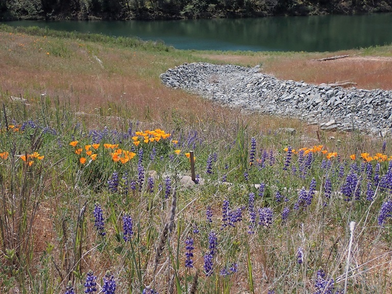
Loafer Creek Fuels Reduction Work
The Department of Water Resources (DWR), in partnership with Butte County Fire Safe Council (BCFSC), started a 13-acre vegetation management project along Highway 162 and Loafer Creek Road on April 22. Green Mountain Contracting is using hand crews to thin and chip overgrown and hazardous vegetation. A one-lane road closure will be needed along the entrance to Loafer Creek Recreation Area when crews are chipping.
CAL FIRE continues hazardous fuels reduction activities at Loafer Creek within the North Complex wildfire burn scar. Crews are using heavy equipment and hand crews to cut, pile, and chip burnt vegetation and trees. The piles will be burned this fall when conditions are safe to burn. Both projects are visible to motorists on Highway 162. The public is advised to use caution around work activities and reduce speeds around crews and equipment.
This work is part of DWR’s Fuel Load Management Plan (FLMP) to reduce wildfire risk, increase public safety, and enhance forest health in areas around Lake Oroville. To date, approximately 700 acres have been treated around the Lake Oroville area by DWR and its partners including CAL FIRE, the California Conservation Corps, BCFSC, Butte County Sheriff’s Office, and California Department of Parks and Recreation. DWR has the goal of treating and/or retreating an additional 1,000 acres over the next 5 years.
Restoration of Spillway Hillside
The hillsides near Oroville Dam’s reconstructed main spillway are blooming with flowers and vegetation in areas which received an application of a hydroseed mix for site stabilization and erosion control in 2019. The hydroseed mix helps to reestablish a root structure in the soil profile to hold it in place by growing sterile grasses which have strong root systems. As these grasses naturally decompose, they add volume and nutrients to the soil profile.
Winter and spring rains over the past two winters have made the ‘improved’ soil better able to support the germinating of the native species seeds also included in the 2019 hydroseed mix. Native species such as yarrow, fescue, California poppy, fiddleneck, and lupine help to restore natural ground cover and improve soil conditions. Hydroseeding is one component of the Oroville Spillways Emergency Recovery Project’s site rehabilitation activities that are scheduled over the next several years.
Summer Hours In Effect at Spillway
Summer access hours of 5 a.m. to 11 p.m. daily are now in effect for the Spillway Boat Ramp Area, Spillway Day Use Area, Potter’s Ravine and North Fork Trails, as well as access to the top of the “Burma Climb” portion of the Brad Freeman Trail which is popular with mountain bikers for its challenging downhill route.
Hours of access to Oroville Dam Crest Road for motorists, bicyclists, joggers, and walkers is 5 a.m. to 11 p.m. year-round. Please note that overnight parking in the lot above the main spillway is not permitted.
Oroville Recreation
The Lime Saddle, Bidwell Canyon, and Spillway boat ramps are open for use. Bidwell Canyon and Lime Saddle boat ramps are open 24-hours per day and the Spillway boat ramp is now open from 5 a.m. to 11 p.m. daily. The Loafer Creek Boat Ramp remains out of the water. Construction of the brand-new Loafer Point Boat Ramp is nearing completion and will be open later this spring.
The California Department of Parks and Recreation (CA Parks) has opened their camping reservations for camping areas around Lake Oroville, including the Lake’s floating campgrounds. Lime Saddle group camping remains closed.
Reservations for camping can be made online by selecting the ‘Reservations’ tab on the Lake Oroville State Recreation Area (LOSRA) webpage. The reservations system needs 48 hours’ notice to process reservations. “Day-of” access to campgrounds is possible if campsites are available. All day use facilities at Lake Oroville State Recreation Area (LOSRA) are open. The Lake Oroville Visitor Center remains closed due to COVID-19 restrictions.
DWR and CA Parks invite outdoor enthusiasts to visit the area’s 91 miles of trails, including the 41-mile long Brad Freeman Trail. Mountain bikers, hikers, equestrians, and bicyclists can find trail information on DWR’s interactive map on the Lake Oroville Recreation webpage.
Visit the California Parks LOSRA webpage for current information on facility status as well as current requirements to protect public health during the COVID-19 pandemic. For information about the Oroville Wildlife Area, including the Thermalito Afterbay, visit the California Department of Fish and Wildlife webpage.
Current Lake Operations
The elevation of Oroville’s reservoir is about 729 feet elevation and storage is about 1.49 million acre-feet -- 42 percent full and 53 percent of historical average. Currently, in the Northern Sierra Basin, rainfall is below average, at 48 percent of normal for this time of year and snowpack is also below average at 27 percent of normal. Rain is forecast this weekend through Monday, April 26, with the heaviest precipitation occurring on Sunday, April 25. Warm, dry weather returns for the remainder of the week.
DWR continues to plan to reduce releases to conserve water while maintaining flows to meet Bay-Delta water quality needs and outflow requirements. Currently, the total flows to the Feather River remain at 1,100 cubic feet per second (cfs) - 800 cfs down the low flow channel through the City of Oroville and 300 cfs through the Thermalito Afterbay Outlet (Outlet). From April 26 to April 30, releases to the Feather River will decrease from the current 1,100 cfs to 800 cfs. At that time, flows down the low flow channel through the City of Oroville will be 650 cfs and 150 cfs from the Thermalito Afterbay Outlet (Outlet) for a total of 800 cfs downstream of the Outlet.
The public can track precipitation, snow, reservoir levels, and more at the California Data Exchange Center at www.cdec.water.ca.gov. Lake Oroville is identified as “ORO”.
All data as of midnight 4/22/2021